|
| Journals |
|
Journals 2013
|
|
Journals 2012
|
|
Journals 2011
|
|
Journals 2010
|
|
Journals 2009
|
|
Journals 2008
|
|
Journals 2007
|
|
Journals 2006
|
|
Journals 2005
|
|
December 2005-TX, LA, AL, FL
|
|
November 2005-AZ, MEXICO, NM, TX
|
|
October 2005-CA, AZ, UT, NV, AZ
|
|
September 2005-CA
|
|
August 2005-MT, WA, OR, CA
|
|
July 2005-WI, IA, SD, ND, MT
|
|
June 2005-FL, AR, MO, WI
|
|
May 2005-FL
|
|
April 2005-FL
|
|
March 2005-FL, TX, FL
|
|
February 2005-FL, CA
|
|
January 2005-FL, MO
|
|
| August, 2005 |
 |
August 1-2
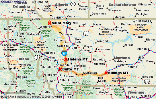
Traveled west via I94/I90 to Butte, MT, then I15 north to Helena, MT and spent the night in the Helena Campground and RV Park. It was a nice little park that offered lots of amenities but a little on the costly side ($26). The drive was through western plains, then into the Rocky Mountains & crossed the continental divide a few times before getting to Helena. The scenery is beautiful; you could see snow in some of the mountaintops.
Tuesday morning, we headed north on I15 until we got to Shelby, then went west on US2 through Cut Bank, then took US89 north to St. Mary on the eastern edge of Glacier National Park. The park campgrounds were full, so we spent the night at the KOA campground. The view is spectacular, mountains surround us and there are prairie dogs running around the campsites. It didn�??t get dark here until almost 10:00 pm. It also got really cold during the night and we had to put on extra blankets and turn the furnace on in the morning. Lucy was just shivering so I even put a blanket over her, she loved it and curled up and went back to sleep again. We weren�??t too impressed with the KOA ($36), the sites were all in the open and it was very crowded.
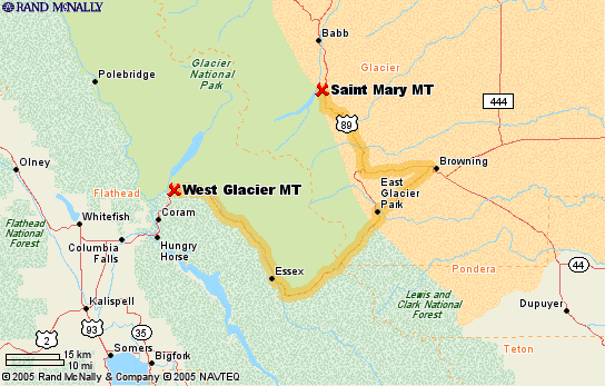
At Glacier, we found out that we can�??t drive the Volksbox on the Going-to-the-Sun Road that goes through Logan Pass and the park because we are too high and too long to get through the pass. There are tour buses that go through, but we would have to leave Lucy in the motor home all day and I don�??t think that would work either. We�??ve decided to go to Babb, then drive into the park as far as Many Glaciers campground to see if we can stay there a few days. That will take us pretty close to Logan Pass and we will see a good part of the eastern side of the park. When we got to Many Glaciers, we found that all of the campsites were full, so we headed for West Glacier where there were open sites.
|
August 2-5
There were open sites at the Fish Camp campground on Lake McDonald, so we picked our site and set up camp for the next few days. This is our first experience �??dry camping�?� since the park has no electric or water at the site. It gave us a good opportunity to check all of our systems and to see how long we could go. Everything in the Volksbox works fine and we have been able to run the generator for 2-hour periods throughout the day, which has been good enough to make coffee, cool down the fridge, and heat up water for washing and showers.
On Thursday, we decided to ride our bikes into Apgar Village to get firewood but we were both so out of shape that we had a hard time making it up the hills. We gathered enough wood for a campfire along the side of the road and hauled it back to the campsite. Will have to get back in shape to be able to take longer rides in the future.
In the evening, a park ranger did a presentation about medicinal plants in the amphitheater. This topic was right down my alley, but Mike also found it to be quite interesting. Mike learned that gin, which is made from the juniper plant and is good for calming the nerves and for cleansing the body. Guess we will have to restock.
|
 |
 |
August 6
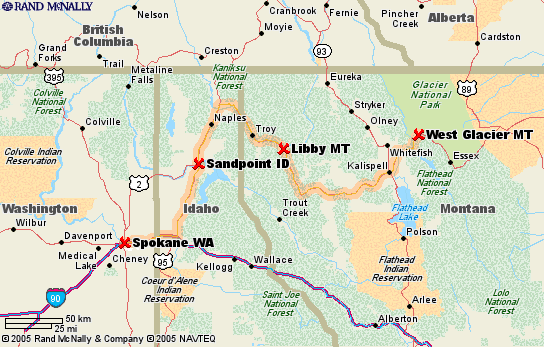
After leaving West Glacier, traveling west on US2, we stopped at Hungry Horse for a piece of huckleberry pie since this is the season for huckleberries. They tasted a lot like blueberries and the woman who made the pies has been doing it for the last 18 years. Needless to say, they were excellent.
The next stop along the way was to view the falls at Kootenay Falls for a small county park. We decided to take Lucy along for the walk, but that proved to not be a good idea since there was a bridge made of steel material that she couldn�??t walk across. Mike stayed back with her while I went ahead and saw the falls and took a few photos.
As we crossed through the panhandle of Idaho, the scenery changed; the hills softened and we traveled a stretch of fifty miles or so along the Pierce River that was absolutely gorgeous. We stopped for the night in Spokane, WA at the Alderwood RV Resort ($27), billed as a �??premier�?� resort that was very nice. The sites were small, but nicely landscaped. The resort had very nice amenities, such as a swimming pool, hiking path, and free wi-fi internet access. We decided to stay for 2 night so we could get prescriptions filled, do laundry, get our filthy motor home washed, and update the website.
|
August 8-9
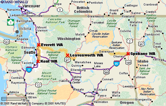
Today we traveled 326 miles across Washington on US2. The scenery changed from dusty, rolling, wheat & barley fields, and lots of dirt devils (little dust tornadoes) in the plowed fields until we got to the Columbia River. It then changed to sharp, rocky cliffs and rock formations. As we got closer to the Cascade Mountain Range and Seattle, we saw views of evergreen covered mountains. A stop at a fresh fruit stand along the roadside provided us with peaches, prunes, and apples for the next few days.
Once again, a huge logging truck sent rocks against our windshield that caused 2 more starbursts to appear. Will have to call the insurance company once more.
When we got to Kent, just south of Seattle, we stopped at Poulsbo RV because they had a Minnie that we wanted to look at. As it turned out, they didn�??t have the one that we saw on the internet, so we really weren�??t interested �?? we keep coming back to our little Volksbox is the best deal going for us right now. We spent the night parked in the driveway of the salesman, Dan�??s house. Since we arrived late in the evening, he offered his place to us and we had a very nice visit with him and his girlfriend Mimi, his son & their dogs and sat on his deck and enjoyed a glass of wine and some good conversation. We couldn�??t have asked for better hospitality �?? he even left a newspaper on our doorstep in the morning.
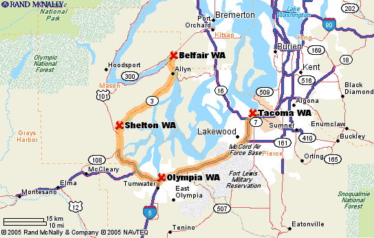
Tuesday takes us to a Flying J at I5 and Port of Tacoma for another repair to the windshield. It�??s a good thing we have our comfortable home with us wherever we go. It�??s another beautiful, sunny day with highs in the upper 70s and lows in the upper 50s �?? PERFECT! It turned out that the windshield couldn�??t be repaired, so we have an appointment for the morning to get it replaced. We spent the night at Majestic Mountain RV park near Puyallup.
|
 |
 |
August 10-11
August 10-11
The windshield was replaced and it cost us nothing �?? our insurance handled it all. They were just great in contacting the repair place, setting up the appointment, and handling the charges.
After that, we drove to Belfair State Park ($22), just north of Olympia. It was a very nice, campground in the Kitsap Peninsula. On Thursday, we drove up to Keyport to visit the Naval Undersea Museum that covered underwater warfare, torpedoes, mines, and submarines. I got to graze on a snack of blackberries, they are everywhere along the road and the parking lot is surrounded by huge bushes. We stopped at the mall in Silverdale to get a little taste of city before returning to the campground, but we both walked out empty handed.
We grilled some fresh, local salmon, had a glass of wine with dinner by candlelight (thanks to Bob�??s gift of the sailboat candle holder).
|
 |
August 12-13
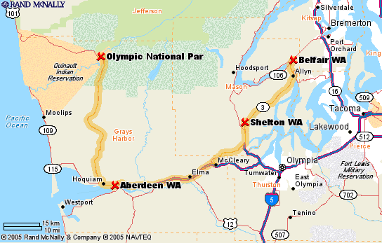
We got up early to travel, grabbed an Americano coffee (espresso with hot water added to it) and headed for the Hoh Rain Forest campground in Olympic National Park �?? this place was referred to us by a gal from Laramie, WY that we met while camping in North Dakota. What we thought would be a 3-4 hour trip took us 6 hours, we are glad we started out early in the morning. The drive was very nice; gray skies & drizzle; evergreen covered hillsides; a multitude of wildflowers along the roadside and the closer we got, a view of the snow-capped Mt. Olympus in the distance at 7,965 feet. Roadside signs that we had never seen before warned us of tsunami hazards and evacuation routes.
Once we got settled into our beautiful and spacious campsite (a bargain at $10/night), we took a walk, had dinner, and went to hear the ranger�??s talk on the history and animals in the national park; black bear, cougar, marmots, raccoons, black-tailed deer (we saw mom and 2 young while we were selecting our campsite). The program was interesting and informative. The glacier-fed Hoh River that flows through here is fast moving and its grayish color is one that I had never seen before. Salmon fishing is closed right now in the park, but I�??m not quite sure why.
When I got up this morning to let Lucy out, there was a deer having breakfast in our campsite. We decided to have our coffee at the campfire and both agreed that we like that a little better than at night, since we have a hard time staying up late these days. In the afternoon, we went on one of the ranger led hikes through the Trail of the Mosses. We learned that this area is a temperate rain forest that gets about twelve feet of rain a year plus the fog most of the year that provides additional moisture. The hike took us through five hundred year old moss-covered Sitka Spruce, Douglas Fir, and American Hemlock trees. Some of the spruce trees were over two hundred feet tall. It is a beautiful place and we are so glad that we added this to our list of places to visit.
|
 |
August 14
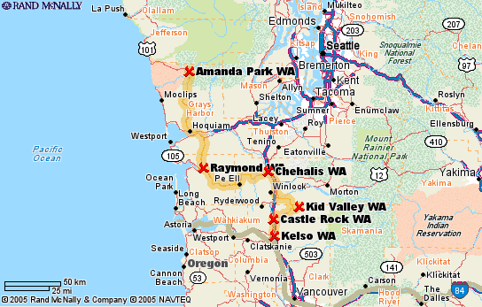
After coffee and a morning walk with Lucy, we left this place to head for Mt. St. Helens, about 200 miles south of here. The drive was beautiful and took us through some of the south Washington farmlands once we got away from the coast. You got a little taste of Swiss heritage as you drove by the small hillside farms.
Once we got within 50 miles of Mt. St. Helens, the terrain changed once again to evergreen covered mountains and you could see Mt. St. Helens and Mt. Rainier in the background. We went to the Johnston Ridge lookout that was directly across from the volcano and you could see puffs of dust rising, from the hot magma inside that was pushing it upwards. This year was a good time to visit because the volcano became active again last September, prior to that it had been inactive since 1980.
We spent the night at the Brookhollow RV Park in Kelso, WA ($23).
|
August 15 - Kelso-Netarts
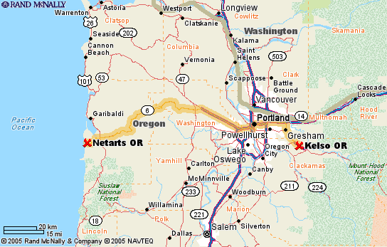
We drove straight through Portland, then stopped at Hillsboro to stock up on groceries, get haircuts, have a burger, and picked up some miscellaneous supplies. One of our reference books said the drive to the beaches would take us through wine country, but it didn�??t really appear that way to us. Netarts is a very small town on the Netarts Bay, so the campground does not sit on the ocean beach, but on the bay. The view of the bay is very nice with plenty of seagull activity and seals off in the distance on a stretch of beach. In the morning, after the tide came in they moved to a sandbar that was much closer to us.
|
 |
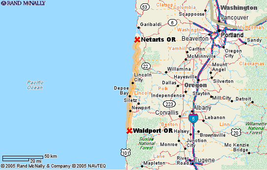 |
August 16-20 - Netarts-Waldport
Today, we headed south on US101 along the coast in hopes of finding a nice campsite close to the beach. No such luck, they were all filled, so we ended up at a KOA near Waldport. It�??s a pretty nice setup, on the Alsea Bay. This is the first small town past a whole series of towns that are more geared toward the tourists, with lots of shopping, beaches, dunes, etc. Once again, we try to avoid those areas and go to the less populated, less visited areas. After a few days in a campground with no hookups, we tend to like one that has it all; laundry, cable TV, internet, full hookups, etc.
On Thursday, we took a walk along the beach that sits at the foot of a hill that leads from the campground. It was cold and windy in the campground but the beach was sheltered from the wind and was very warm. We found a huge piece of driftwood to lean against and sat enjoying the sunshine. As we sat there, we watched a seal bobbing in the water fairly close to shore. We commented that the seal was lying on its back and that its flippers were sitting out of the water, it was enjoying a back float. An arm raised out of the water, then the head became more clear, complete with goggles and diving gear - it was a diver. The joke was on us.
I sat at the window, surfing the net and enjoying the view when an Anna's hummingbird came buzzing right up to the window. It is one of the most common hummers found in this area. As we sat around the campfire this evening, it came back several times and fed on the fuscia shrubs that surround our campsite.
|
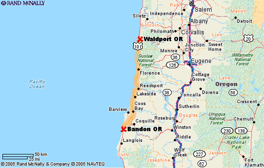 |
August 21, Waldport to Bandon, 106 miles
Left Waldport today and headed south again along the coast as far as Bandon and a stop for the night at Bullards Beach State Park. The Cape Perpetua Overlook was a great place to stop to view the rocky shoreline. Along the hiking trail, we stopped to talk to an older man who told us that he had been stationed there in the army back in 1942 and their job was to test radar. The location wasn�??t good for that purpose, so they were moved to different areas along the coast. A stone structure built by the CCC in 1930 as a lookout for enemy ships and planes was a little further down the path and provided some excellent views.
We saw a herd of elk along the roadside, close to a small community. Unfortunately, there was traffic and we weren't able to stop to take photos.
We stopped at the grocery store in Bandon and rented Kevin Spacey�??s movie, Along The Sea, the story of Bobby Darin. We both enjoyed the movie and it was nice because we had no TV in the campground that night.
|
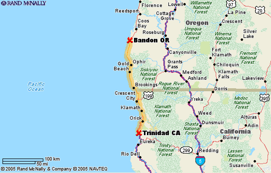
August 22- Bandon to Trinidad, CA, 169 miles
Heading south along US101 again, we crossed into California today and drove part of the Redwood Highway. The lumber towns along this stretch are really small and not real attractive. Our camping spot for the night was Patrick�??s Point State Park just north of Trinidad, a cute little coastal town with a replica of a small lighthouse in the �??Old Downtown�?� area.
The campground had no hookups, it was cold and foggy, so we hung out in the Volksbox and had gin and tonics and played dominos. There were signs posted, cautioning that bear and mountain lions had been spotted in the park recently. Each campsite had a bear proof container for keeping food and you were advised to keep all food away from tents and in the trunks of vehicles. Blueberries and blackberries were in abundance, so there was plenty for them to eat.
Before we left in the morning, we took a walk to view Patrick�??s Point in the fog, then headed out once more.
|
 |
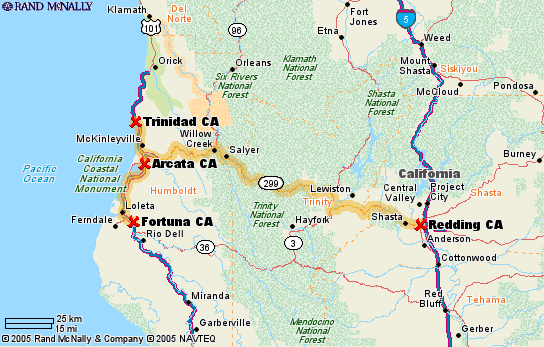 |
August 23-Trinidad to Redding, 206 miles
Mike�??s 58th birthday. We drove south as far as Fortuna for a stop at a bakery and the C Crane radio store. Then back north to Arcata where we headed east along CA 299, Trinity Highway, toward Redding. This road wound through the mountains along the Mad River and Trinity River to elevations of 3,000 feet. The countryside was beautiful and the Trinity River was a fast moving, rocky, emerald green river.
We saw several gold digging operations along the way. They were suction dredges that suck the sand up and across a sluice box, looked pretty sophisticated. One flew the scull and crossbones flag and had a sign on it that said, �??Pirates Cove, We�??re In It For The Booty�?�. The apparatus was like a motorized vacuum that sucked up the river bottom and drew it along a belt.
Weaverville was a really cute little town. From there to Redding was a 13-mile stretch of road that we traveled at a speed of 20-30 mph and was hairpin curve after hairpin curve �?? a great Miata road, not bad in the Volksbox, but it sure wouldn�??t be much fun in a larger motor home. We met a lot of logging trucks along the way.
The next 2 nights were spent at the Mountain Gate RV Park in Shasta Lake ($19). This was a new RV park, nice sites, super clean bathrooms, a pool, dog walk, etc. After a few nights in the state parks, we enjoy having full hookups, cable TV, and internet service.
|
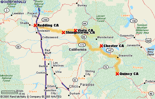
August 25, Redding to Quincy, CA
After talking with the owner of the Mountain Gate RV Park, he suggested we see Lassen Volcanic National Park instead of Mt. Shasta because it was much more scenic & Mt. Shasta was "just another mountain". We took his advice and were so pleased. The 38 mile drive west on CA 44 was very nice, but once we headed south on CA 89 that went through the park and to the peak was absolutely gorgeous(the map that is pictured shows a slightly varied route). In fact, we both mentioned that we thought it might have been the most scenic that we had seen on the whole trip.
The first part of the drive was through the devastated area, and it was due to the eruption of the volcano back in 1913 and is now in recovery, trees and plants are now growing. On one side of the road, the hillside would be varying shades of gray rocks and boulders. On the other side of the road would be shades of copper/tan colored rocks and boulders. Emerald Green lakes were scattered here and ther.
Lassen Peak was at an elevation of 10,457 feet and there were glaciers here and there. When we stopped to see the peak, there were huge mounds of snow at the edges of the parking lot. At one point on the drive, we came around a curve and saw clouds of steam rising from the hillside. These were sulphur springs or mud pots, they smelled like rotten eggs and as you got closer to them you could actually hear them bubbling underground.
After leaving the park, the drive continued to be scenic and we passed through some small towns before we stopped in Quincy for the night. A farmers market was being held along the main drag, so we stopped and stocked up on fruits, veggies, and grass-fed angus beef. We spent the night at the Pioneer RV Park ($25).
|
 |
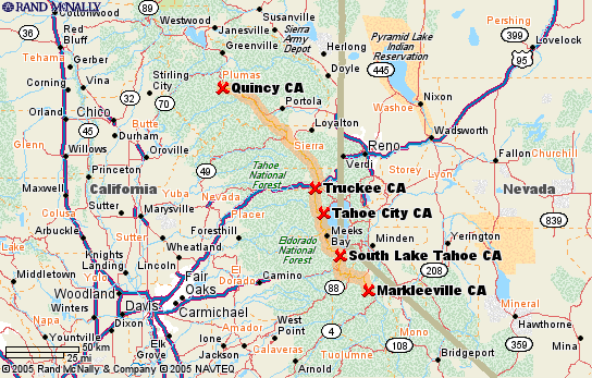 |
August 26, Quincy to Markleeville, CA, 142 miles
Today's route took us through the Tahoe National Forest and the Eldorado National Forest, via CA 89 to end up at Grover Hot Springs State Park for the weekend. Once again, the California countryside was spectacular. Kind of amazing that this route took us nearly 5 hours to drive because of the mountains and curves. We didn't have a reservation but we were lucky to get one of the last 2 sites available. One thing we learned from this stop is NOT to choose a site by the restrooms (traffic, flushing, etc.). Our site was very nice, though, backed by a very large hill with gigantic boulders scattered around. The boulders provided entertainment to the children that were camping here.
As we headed south, we could see a wildfire near Sierraville that we had been hearing of on the news. We could see helicopters dumping materials on the fires, also saw many fire fighting trucks heading that direction and signs pointing to fire camps.
The park provided two pools, one was a hot pool with water from the hot springs. It was 140 degree water, loaded with minerals that was treated to remain at 102 degrees. Next to that pool was a cold water pool. It was very refreshing to go from one to the other.
While sitting in our campsite just before dark on Saturday night, we say a deer come walking next to our site about 30 feet away from us. It appeared somewhat spooked but walked up the hill.
|
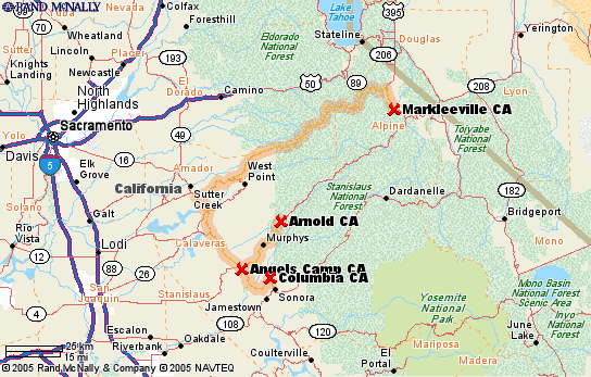
August 28, Markleeville to Columbia, CA, 120 miles
The drive today was AWESOME. The map is incorrect (couldn't get it to show our exact route) and we actually went straight from Markleeville through Arnold & Murphys, not to Sutter Creek.
We didn't realize that CA 4 would go through some of the roughest country we have seen yet. It took us through the Stanislaus National Forest and 4 hours to get 120 miles, so it was pretty slow going. We went up, up, up, and it seemed like we would never go down again. Ebbetts pass was at an elevation of 8700 feet and there were rock cliffs on one side of the road and straight dropoffs on the other side.
Warnings included chains and studded snow tires in the winter, even for 4-wheel drive vehicles. Vehicle length was limited to 25'. We knew it was going to be intense when the center line on the road disappeared and the road narrowed. Fortunately, there wasn't a lot of traffic, but we did pass a truck pulling a camping trailer. This was the first time on the trip that I experienced motion sickness and we were both getting headaches from the elevation.
This area is gold country and the town of Columbia is a state park and is one of the only "living" towns that was established during the gold rush. Apparently many have become ghost towns. We decided to spend the next couple of days at the 49er RV Ranch that has been in business since 1852.
After hanging out in town on Monday, we were headed back to the campground when we heard sirens and saw several fire fighting trucks headed out of town. I was sitting at the campsite reading when I heard 3 airplanes flying over. A fire had stared not too far from here and they got it under control right away.
|
 |
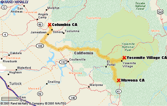 |
August 30, Columbia to Wawona, CA - 112 miles
Another 5-hour trip to go 100 miles. This one through Yosemite National Park and more beautiful vistas. One ooh ahh after another. We spent the night at the Wawona Campground which is at the southern entrance to the park.
We met Bert and Nina from the Netherlands and invited them to share our campfire. Had a glass of wine and shared travel stories with them. They were on their 3rd visit to the US travelling in a rented motor home through the West, mostly visiting Indian historical areas because of Bert's fascination with the American Indian since he was a child. Had a very nice time and learned a bit about life in Holland.
The campsite was located along the Merced River, another beautiful setting. The campsite was very dry and dusty so things got dirty real quick.
|
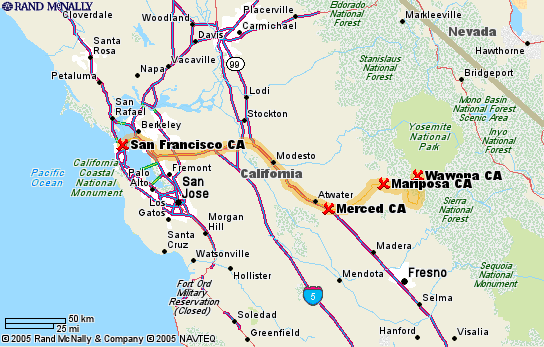 |
August 31, Wawona to San Francisco, 216 miles
The big highlight today was seeing Ben and Jill and Ruby again.
The drive took us through the central valley part of California, then through Oakland, across the Bay Bridge, and on to the Outer Richmond section of San Francisco and Ben's house. The Volksbox (and Mike, the expert driver that he is) handled the city streets very well and we found a place to park near the house.
We now look forward to catching up on lost time with Ben & Jill.
|
Created on 08/01/2005 09:09 AM by bridge
Updated on 09/01/2005 01:47 PM by bridge
|

|
|
|
